

The use of drones and Unmanned Aerial Vehicles (UAV) has been increased in recent years for surveying, monitoring and other relevant fields. However, more recently, the technological progress in the design and navigation of low-weight and autonomous drones and UAVs have resulted in their more practical and cost-effective operation in the fields of engineering, construction management and monitoring.
Many industries are rapidly improving the scientific tools and introducing smart solutions to solve real-world problems. The planning and monitoring of construction activities is one of the key areas where the drones and UAVs can significantly improve the performance and speed. In fact every industry can take the advantage of such technologies in almost the whole range of practical aspects.
For example, the drones and UAVs can be potentially used at several stages in a construction project including pre-planning, detailed survey and mapping of job site, construction process monitoring, post-build checks, and sales and marketing.

Advantages :
The traditional approach for monitoring of projects involves a strict execution of plan without the possibility for any last minute changes. In this approach, the availability of accurate real-time data is very limited. On the other hand, a smart monitoring system is based on organized real time data which is collected using various advanced tools e.g. drone- or UAV-mounted sensors (RGB camera, thermal imaging camera and IR sensors etc.). The data is then analysed using advanced software which allow for better operations, planning and adjustments. Some of the important applications of drones and UAVs in construction monitoring include the following :-
1. 3D Base Map : Aerial Survey provides data for 3D Basemap and area’s orthophoto. The data can be continuously updated and compatible with CAD environment. This provides a better control over the work progress and the ability to provide investors and clients with the most recent visual information.
2. Aerial Photography & Videography : Aerial photo and video can be used to provide clients with impressive visuals such as the view out the future window at the earliest stages of construction. A 3D model of a construction project makes every fine detail available for viewing online. The model can also be used in further planning, including that of landscaping and designing.
3. Construction Progress Monitoring : Throughout a development’s construction phase (and even before), agreed flight paths over and around the site can be made to provide almost real time visual progress reporting for developers, stakeholders and even the people on site as an engaging record of how the project is going.
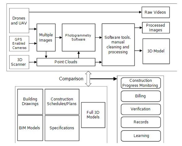
4. Volumetric Measurement : Using accurate aerial photogrammetry techniques, large areas (2D and 3D) can be measured to within accuracy in centimetres. This can be accomplished quickly, cost effectively and with minimal disruption to the day to day workings of the site. The data obtained from drones and UAVs can then be analysed using various software to extract useful information for decision-making. In recent years, several image processing softwares, computer vision, and geometrical processing techniques are developed which can either generate reality 3D models from the collections of overlapping images, or can be used to manually or semi-automatically conduct progress monitoring, surveying, safety inspection, quality monitoring and activity analysis during the construction.
Conclusion:
The technological progress in the design and navigation of low-weight and autonomous drones and UAVs can be efficiently used in a dynamic manner to result in a more practical and cost-effective operations in the fields of construction management and monitoring. It is shown that this fully automated system i.e. Drone can significantly reduce the effort required in traditional construction monitoring and reporting procedures. The system not only provides convenient and smart ways of site supervision and management but also results in better operations, planning and effective on-site adjustments.
Author :
 Mr. Harshvardhan Singh Rawat
Bussiness Development manager, Globe View Technologies
Globe View Technologies has vast experience in Modern Survey Technologies for planning, monitoring and analysis, using Drones & LiDAR technology for different infrastructure projects by closely working with different Highways and Railway sectors in different stages such as planning and construction by providing them advanced solutions & best services with International Standards.
