

Globe View Technologies has been appointed to undertake the drone survey of portal areasand station areas of different packages for new broad gauge rail link between Rishikesh-Karnprayag in the state of Uttarakhand. Globe View worked with RVNL (Rail Vikas Nigam Limited) to introduce a technological solution for innovating the design phase and avoiding the delay of the programme.
This 125 km route starts at New Rishikesh railway station at 380m AMSL and ends at Karnaprayag 825m AMSL. It will reduce Rishikesh to Karnaprayag travel time from 7 hours to 2 hours. A 15.1 km tunnel, reported to be the country’s longest, will be built between Devprayag and Lachmoli on the route.
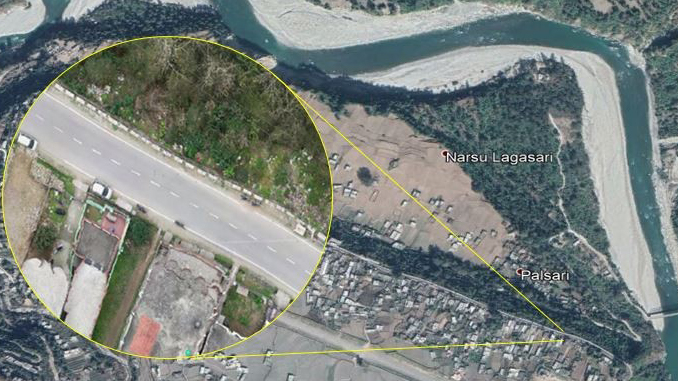
To support early-stage design and final location survey RVNL needs highly accurate survey data of a large area composed of a complicated terrain, road, steep hills, greenfield and urban areas. So RVNL need a highly experienced team to work on such tough terrain.
The Project and Challenges
Using a traditional topographical survey method (i.e. using total station) to digitise aprx 1500 hac hilly site could take up to Nine months. This would be far too time-consumingand risky in hilly terrains (terrain height changes upto 500m). UAV survey solutions are less time consuming and safest method and took 1 week for local administration approval.
These area are extremely hard and dangerous to access without disrupting ground activities. Moreover, some areas were completely inaccessible due to very difficult terrain and forest area.
The Solutions
UAV Survey added benefit of removing the serious risk associated with putting workers on the ground in a difficult hilly terrain. The captured UAV data included 2.3 bn data pointsand 15,000 images, which were captured, processed manually using photogrammetry technologies and quality assured in 1.5 months. UAV Survey reduces the time to conduct survey from nine months to 1.5 months.
Deliverables
Globe View have delivered 3cm GSD Orthomosaic, 50cm Contour, DSM, DTM, DEM, 3d reality Model and 3d Topographical file.

This output data can be used with CAD and BIM to provide an incredibly detailed and versatile digital environment. This added a great value to the output of Drone data as compared to traditional survey data.
Project Summary
Area: 1500 Hac
Images captured: 15000 Images
Accuracy: 5cm RMSE
Deliverables: DTM, DSM, DEM, Contour, 3d Reality Model, 3d Topographical plan file
Project Duration: 2 Months
Author :
 Mr. Harshvardhan Singh Rawat
Bussiness Development manager, Globe View Technologies
Globe View Technologies has vast experience in Modern Survey Technologies for planning, monitoring and analysis, using Drones & LiDAR technology for different infrastructure projects by closely working with different Highways and Railway sectors in different stages such as planning and construction by providing them advanced solutions & best services with International Standards.
